
INDIANAPOLIS — Severe storms brought tornadoes and hail to parts of central Indiana Sunday, leaving behind significant damage.
The hardest-hit area in central Indiana was in northern Johnson County, where a tornado caused extensive damage to dozens of buildings in a line estimated by officials as roughly three miles long.
Fortunately, no serious injuries have been reported in that storm as of Monday morning.
Track updates on storm damage and recovery efforts in our live blog below.
Updates
Monday, June 26:
10 a.m. - Indiana Gov. Eric Holcomb said the Indiana Department of Homeland Security will have staff on the ground in the coming days in a statement issued Monday morning:
6:15 a.m. - Center Grove Schools announced that due to power outages and storm damage, no activities will be held at Central Grove High School, Center Grove Middle School Central or Center Grove Elementary on Monday.
5 a.m. - Two National Weather Service teams will respond to Johnson County Monday morning to survey damage there. One team will respond to Daviess, Martin and southwest Monroe counties. The teams will assess damage and work to determine the track and category of tornadoes that touched down.
Sunday, June 25:
9:20 p.m. - 13News crews and viewers have shared images of major damage to homes in multiple Johnson County neighborhoods:
8:35 p.m. - The National Weather Service Indianapolis office says two survey teams will be sent to Johnson County to look at damage, and another team will respond to an area of damage in Martin/Monroe counties.
8:30 p.m. - DroneCam 13 captured video of some of the damage to homes in Johnson County:
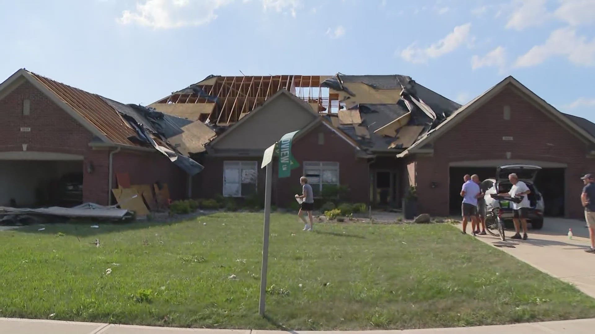
8:20 p.m. - During a news conference Sunday evening, Bargersville Fire Department Chief Eric Funkhouser said no serious injuries had been reported in the area, and 75 homes received moderate to severe damage. Crews have been conducting search and rescue operations since around 4:15 p.m. and have completed a primary search of all impacted buildings.
Officials estimated a roughly three-mile long path of damage from the tornado, from the area of Travis and Mullinix roads to south of Center Grove High School and across State Road 135 to the Stones Crossing area.
Crews have been working to clear roadways and conduct secondary searches of impacted buildings.
Officials are asking people to avoid the area of possible as crews clean up. Powerlines remain down throughout the area. A curfew will be in place from 9 p.m. Sunday to 6 a.m. Monday, police said.
The Red Cross has set up at Greenwood Middle School for anyone impacted in need of shelter. Anyone coming to the school should enter through door 6.
Johnson County REMC had around 3,700 customers in the area without power Sunday evening, down from well over 10,000.
Indiana DNR crews were requested to the area to help remove large trees from roads.
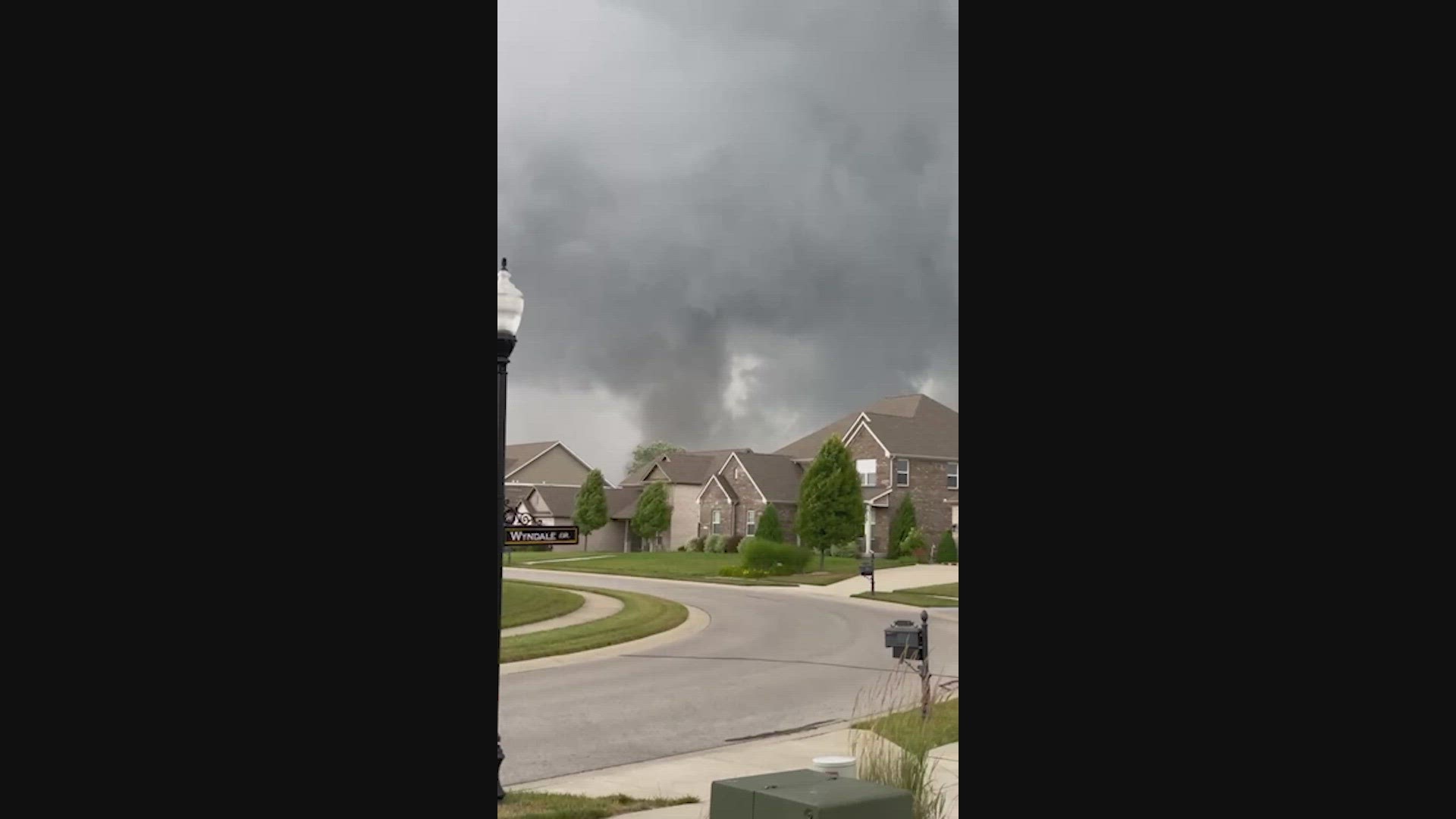
6:57 p.m. - Cody Likens caught video of a tornado passing Emmanuel Church – Greenwood campus.
6:46 p.m. - A Tornado Watch for Fayette and Wayne counties is in effect until 11 p.m.
6:26 p.m. - For those who were left without a place to stay as a result of the storms, the American Red Cross will have a shelter at Greenwood Middle School. It should be open at 7 p.m. and is at 1584 Averitt Road.
6:24 p.m. - Here are the road closures in Johnson County from the storms:
- Travis Road is closed between Mullinix Road to Morgantown Road
- Morgantown Road from Mullinix Road to Whiteland Road
- Stones Crossing Road from State Road 135 to Saddle Club Road
- Saddle Club Road from Stones Crossing Road to Smokey Row Road
6:14 p.m. - Authorities in Johnson County are asking people to stay home and out of the area. There are downed power lines that are still live as crews work to shut off the power. There is also widespread debris. Emergency crews are working to check on people, clear areas and get resources and temporary shelter to those who have lost their homes.
6:10 p.m. - The area down by Crane Naval Base also got hit by the severe storms.
6:01 p.m. - Bargersville Community Fire Department Chief Eric Funkhouser captured video of one of the tornadoes.
5:55 p.m. - Unfortunately, we're starting to see more of the damage from the storms and the homes hit.
5:51 p.m. - Johnson County Sheriff Duane Burgess sent the following information on the tornado damage to 13News:
Parts of northern Johnson County has been hit by a tornado and the damage area covers a very large area. Several neighborhoods and homes have been damaged or destroyed. We are asking that if you do not live in the area please stay out of the area because you are hindering the work of Emergency workers.
Law Enforcement has already closed several roads in the area.
More information will be released as we collect damage reports form from Emergency workers.
5:45 p.m. - A Tornado Warning is in effect for Jackson and Jennings counties until 6:15 p.m.
5:42 p.m. - Here is another video of the Stones Crossing tornado courtesy of Erik Hopper.
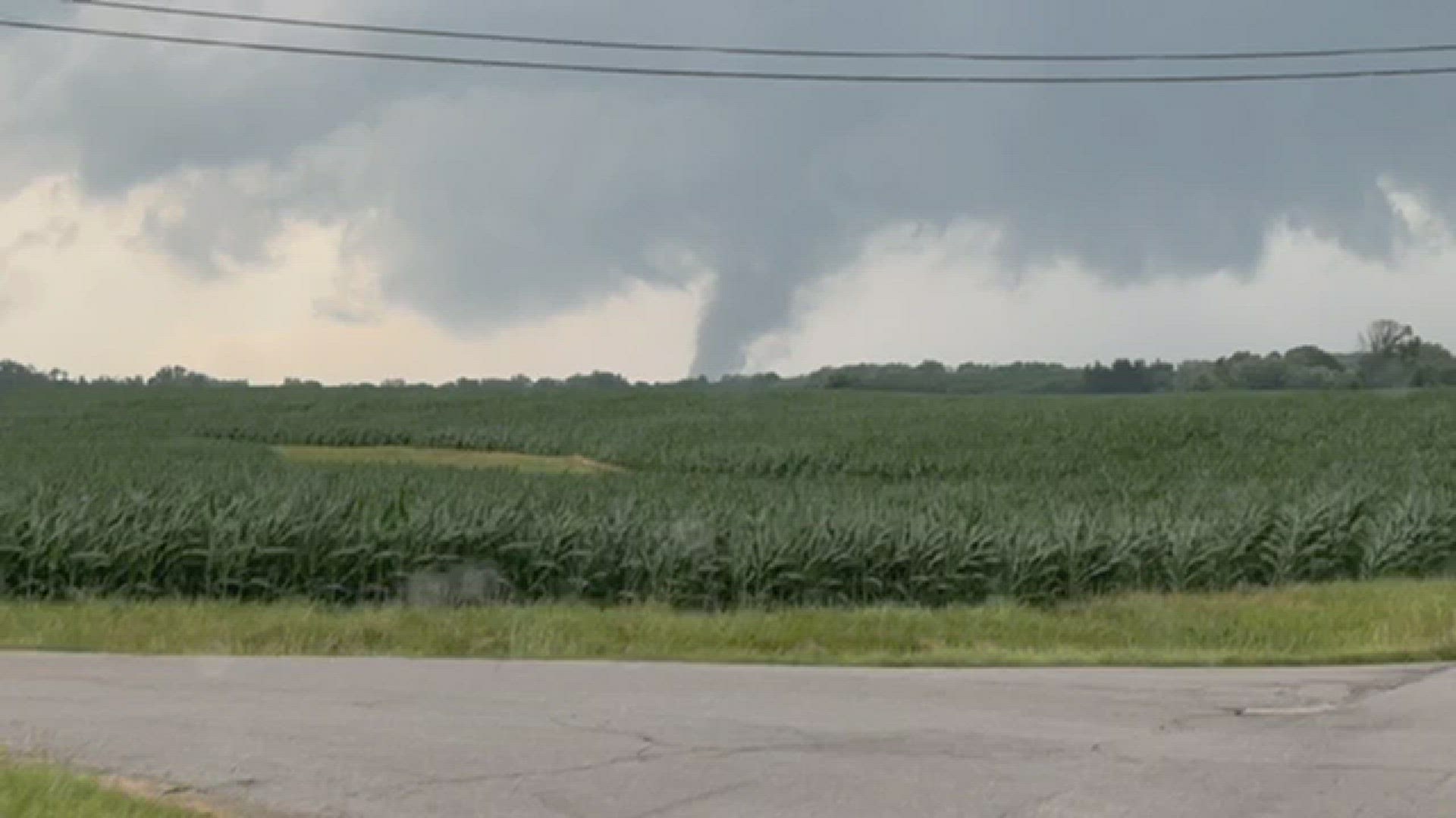
5:35 p.m. - A tornado hit the Flats of Stones Crossing in Johnson County. The good news is that most of buildings are still under construction and there were no injuries. This video is courtesy of Eric Ford.
5:27 p.m. - Duke Energy reports 8,396 customers are without power. AES reports 382 power outages in the Indianapolis area.
5:21 p.m. - A Tornado Warning continues for Seymour, Brownstown and Crothersville until 5:45 p.m.
5:14 p.m. - The Tornado Warning for Brown, Lawrence and Monroe counties has been canceled. It continues for Jackson County until 5:30 p.m.
5:10 p.m. - Police tell 13News that there are multiple structures collapsed in the Center Grove area from the storms.
5:02 p.m. - Video from Bargersville, Indiana shows a tornado. This is courtesy of Brent Sweeney.


4:54 p.m. - Duke Energy reports 6,036 customers are without power. AES reports 325 power outages in the Indianapolis area.
4:45 p.m. - A Tornado Warning is now in effect for Brown, Jackson, Lawrence and Monroe counties until 5:30 p.m.
4:33 p.m. - A Tornado Warning is in effect for Johnson, Marion, Rush and Shelby counties until 5 p.m.
4:22 p.m. - A confirmed tornado is reported near New Whiteland. Law enforcement tells 13News there are collapsed structures.
4:19 p.m. - A Tornado Warning is in effect for Johnson and Shelby counties until 4:45 p.m.
4:15 p.m. - A Tornado Warning continues for Hamilton, Madison and Tipton counties until 4:30 p.m.
4:12 p.m. - A Tornado Warning is in effect for Brown, Monroe, Morgan and Owen counties until 5 p.m.
4:03 p.m. - Hamilton County is seeing ping pong-sized hail or larger in areas.
3:54 p.m. - A Tornado Warning is in effect for Hamilton, Madison and Tipton counties until 4:30 p.m.
3:49 p.m. - A Tornado Warning is in effect for Clay, Monroe, Morgan and Owen counties until 4:15 p.m.
3:45 p.m. - A severe Thunderstorm Warning is in effect for Morgan, Johnson, Hendricks and Marion County until 4:15 p.m.
3:38 p.m. - Tornado Warning
The National Weather Service in Indianapolis has issued a Tornado Warning for... Southeastern Clinton County in central Indiana... Northeastern Boone County in central Indiana... Northwestern Hamilton County in central Indiana... Southwestern Tipton County in central Indiana... Until 400 PM EDT. At 329 PM EDT, a severe thunderstorm capable of producing a tornado was located 7 miles north of Lebanon, or 8 miles south of Frankfort, moving east at 40 mph. HAZARD...Tornado and ping pong ball size hail. SOURCE...Radar indicated rotation. IMPACT...Flying debris will be dangerous to those caught without shelter. Mobile homes will be damaged or destroyed. Damage to roofs, windows, and vehicles will occur. Tree damage is likely. This dangerous storm will be near... Kirklin around 335 PM EDT. Other locations in the path of this tornadic thunderstorm include Sheridan and Westfield. This includes Interstate 65 between mile markers 143 and 148.
3:30 p.m. - The National Weather Service in Indianapolis has issued a Tornado Warning for Southeastern Clinton County in central Indiana, Northeastern Boone County in central Indiana, Northwestern Hamilton County in central Indiana, Southwestern Tipton County in central Indiana Until 400 PM EDT. At 329 PM EDT, a severe thunderstorm capable of producing a tornado was located 7 miles north of Lebanon, or 8 miles south of Frankfort, moving east at 40 mph. HAZARD...Tornado and ping pong ball size hail. SOURCE...Radar indicated rotation. IMPACT...Flying debris will be dangerous to those caught without shelter. Mobile homes will be damaged or destroyed. Damage to roofs, windows, and vehicles will occur. Tree damage is likely. This dangerous storm will be near... Kirklin around 335 PM EDT. Other locations in the path of this tornadic thunderstorm include Sheridan and Westfield. This includes Interstate 65 between mile markers 143 and 148.
3:33 p.m. - Helpful information from the Department of Public Works
3:30 p.m. - Storm moving into Kirklin.
3:24 p.m. - A Severe Thunderstorm Warning for Boone & Clinton counties is in effect until 3:45 p.m. this afternoon.
3:22 p.m. - Events are being affected by today's storms.
3:14 p.m. - A Severe Thunderstorm Warning for Boone, Clinton & Montgomery counties is in effect until 3:45 p.m. this afternoon.
3:11 p.m. - A Severe Thunderstorm Warning for Hendricks & Putnam counties is in effect until 3:45 p.m. this afternoon.
3:09 p.m. - A Severe Thunderstorm Warning for Owen & Putnam counties is in effect until 3:30 p.m. this afternoon.
3:00 p.m. - From meteorologist Angela Buchman:
The 13 Weather Team continues to track a developing line of severe storms. At 3 p.m., the line was from near Logansport south to Frankfort, Colfax and Greencastle. The individual storms are moving northeast. The line will eventually move east across the state from now through about 8 p.m. There are numerous severe thunderstorm warnings in effect along the line. Please remember a tornado may develop will little warning and a tornado watch is in effect until 8 p.m. Storms may also contain 2” hail and damaging winds. Have several ways to get warnings and tune into 13News and wthr.com for team coverage.


2:49 p.m. - More counties added to ongoing Severe Thunderstorm Warnings.
A Severe Thunderstorm Warning for Boone, Clinton, Montgomery & Tippecanoe counties is in effect until 3:15 p.m. this afternoon.
A Severe Thunderstorm Warning for Montgomery & Putnam counties is in effect until 3:15 p.m. this afternoon.
The 13 Weather Team continues to track a developing line of severe storms. At 3 p.m. the line was from near Logansport south to Frankfort, Colfax and Greencaslte. The individual storms are moving northeast. The line will eventually move east across the state from now through about 8pm. There are numerous severe thunderstorm warnings in effect along the line. Please remember a tornado may develop will little warning and a tornado watch is in effect until 8pm. Storms may also contain 2” hail and damaging winds. Have several ways to get warnings and tune into 13 news and wither.com for team coverage.
2:49 p.m. - Sean offers a heads-up about the potential for hail with these storms.
2:44 p.m. - Strong storm near Westfield.
2:38 p.m. - Severe thunderstorm currently moving between Crawfordsville and Lafayette.
2:34 p.m. - Heavy rain falling near Lafayette.
2:24 p.m. - A Severe Thunderstorm Warning for Clinton, Fountain, Montgomery & Tippecanoe counties is in effect until 2:45 PM this afternoon
Much of central Indiana is now under a Tornado Watch until 8 p.m. We're monitoring west-central Indiana for storm initiation along an approaching front/wind-shift that will trigger storm development in the coming hours.