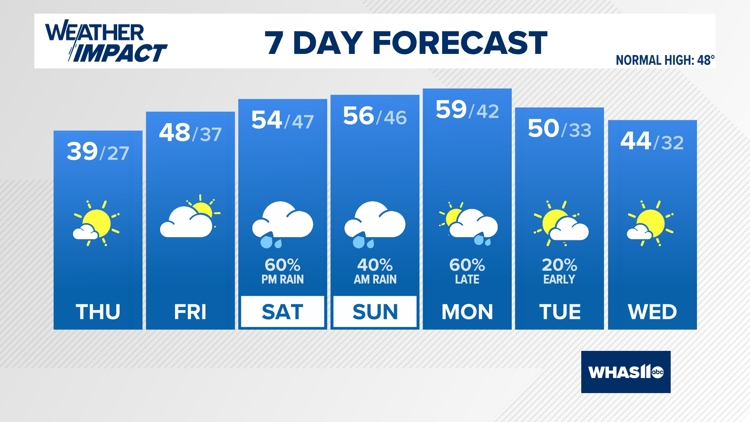
Weather Headlines
- Coastal North Carolina hit by flooding as Tropical Storm Ophelia travels north
- Tropical Storm Ophelia off the mid-Atlantic coast producing winds just below hurricane force
- When does fall start? A look at the autumn equinox
- When is the harvest moon supermoon this month?
- Climate change could bring more monster storms like Hurricane Lee to New England
10-Day Forecast
Mon
Sep 25
85
63
20%
9
MPH
SSW
Clear. Lows overnight in the low 60s.
65%
N/A
7:33 AM
7:35 PM
Tue
Sep 26
87
64
20%
9
MPH
WSW
Mix of sun and clouds. Highs in the mid 80s and lows in the low 60s.
65%
High
7:34 AM
7:34 PM
Wed
Sep 27
85
64
40%
9
MPH
NW
Morning showers and thunderstorms. Highs in the low 80s and lows in the mid 60s.
64%
Moderate
7:35 AM
7:32 PM
Thu
Sep 28
80
63
60%
9
MPH
NNW
Thunderstorms early. Highs in the low 80s and lows in the low 60s.
65%
Moderate
7:36 AM
7:31 PM
Fri
Sep 29
83
63
0%
8
MPH
N
Plenty of sun. Highs in the low 80s and lows in the low 60s.
67%
High
7:37 AM
7:29 PM
Sat
Sep 30
84
64
0%
8
MPH
S
Sunny. Highs in the mid 80s and lows in the low 60s.
66%
High
7:37 AM
7:28 PM
Sun
Oct 01
85
64
0%
8
MPH
NNW
Sunny. Highs in the mid 80s and lows in the upper 50s.
60%
High
7:38 AM
7:26 PM
Mon
Oct 02
85
63
0%
8
MPH
SE
Abundant sunshine. Highs in the mid 80s and lows in the upper 50s.
55%
High
7:39 AM
7:24 PM
Tue
Oct 03
86
62
0%
8
MPH
NE
Mainly sunny. Highs in the low 80s and lows in the upper 50s.
55%
High
7:40 AM
7:23 PM
Wed
Oct 04
85
57
0%
7
MPH
N
Plenty of sun. Highs in the mid 80s and lows in the upper 50s.
55%
High
7:41 AM
7:21 PM
Hourly Forecast
2 AM
Tue
68°
0%
5
MPH
ESE
3 AM
Tue
67°
0%
5
MPH
ESE
4 AM
Tue
66°
0%
3
MPH
ESE
5 AM
Tue
65°
0%
4
MPH
ESE
6 AM
Tue
63°
0%
4
MPH
ESE
7 AM
Tue
63°
0%
3
MPH
SE
8 AM
Tue
63°
0%
3
MPH
ESE
9 AM
Tue
66°
0%
3
MPH
SE
10 AM
Tue
71°
0%
4
MPH
SSE
11 AM
Tue
76°
0%
5
MPH
SSE
12 PM
Tue
80°
0%
5
MPH
SSE
1 PM
Tue
82°
0%
5
MPH
SSE