
LOUISVILLE, Ky. — Happy New Year! We've reached 2020, and it's a bit weird to see a second 2 there instead of a 1. Do you believe 2020 is the start of the new decade, or 2021? I'll let you fight among yourselves. Here's to a prosperous year and successful resolutions if you made any. Let's talk about our first storm system of 2020 and at the end of the blog review the weather in 2019.
Forecast at-a-glance:
- Clouds return Wednesday night
- Widespread scattered rain is likely for the second day of the new year
- Rain will continue through Friday
- Some snow flakes are possible late Friday night and Saturday
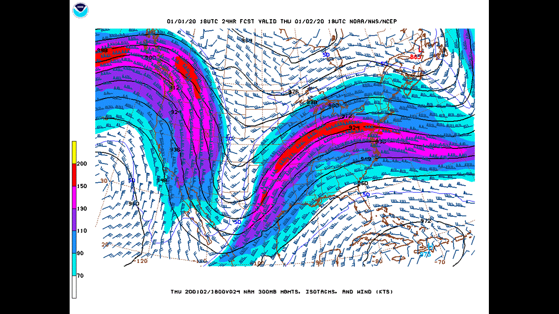
Weather setup: We start in the upper levels of the atmosphere where se notice a very large, deep trough over the Rocky Mountains as of Wednesday afternoon. This trough is beginning to form a low pressure system in the southern Rockies that will slowly move east over the next couple days and bring us our next round of rain (Figure 1). This is a strong jet stream with a strong jet streak embedded in it. This will move over the Ohio Valley Thursday and Friday and help force precipitation to develop.

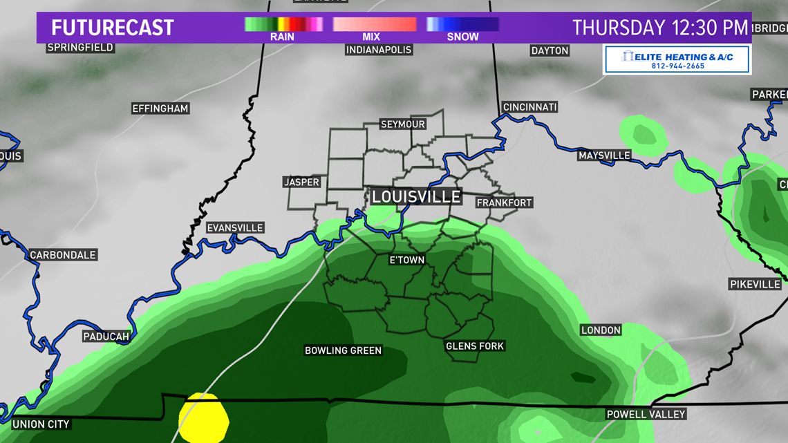
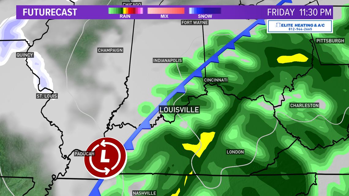
Clouds move back into the Ohio Valley Wednesday night which will help keep temperatures steady heading into Thursday. As the now-formed storm system moves up the Mississippi River Valley rain will as well. We’ll see precipitation move into the Kentuckiana region from southwest to northeast (Figure 2). Metro Louisville will see the onset of rain early afternoon and continue periodically through the night into Friday.

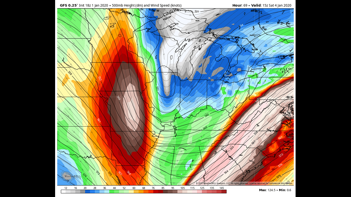
The forecast continues to evolve and gets more interesting on Friday. Another mid-upper level disturbance will be moving southeast out of Canada around the same time Thursday’s rainmaker from the southwest moves into the region (Figure 3). These two systems will interact with one another and produce another cold front that’s going to pack a bit of a punch and bring in some colder air. It’s worth noting that the GFS and Euro solutions are trending further north with this Canadian disturbance and are more in line with what the NAM has been suggesting. A more northerly track would make snow less favorable for us. The Saturday afternoon GFS and European solution is a change from what it had been indicating the past couple of days, which was a more southerly track. We’ll need to monitor how models predict its track.
The cold front will move through later Friday and the cooler airmass will lag a little bit. It’s a strong enough disturbance that the entire atmospheric column, except for the surface, is below freezing. That’s important. With enough moisture and lift in the atmosphere and good conditions for the development of snowflakes, bands of snow showers and mixed precipitation are quite possible late Friday into Saturday morning (Figures 4, 5).


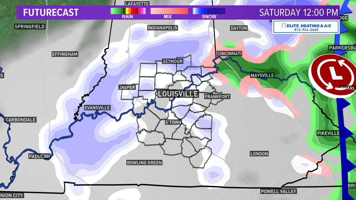
The problem, of course, is temps at the surface remaining well above freezing and the ground being quite warm. While the snow meter is set to ‘Possible,’ it’s important to remember that it discusses the chance to see snowflakes, not accumulating snow. If snowfall rates in these potential snow bands are heavy enough to counteract the warm ground temperatures, some minor accumulation is possible on grassy and elevated surfaces. Again, much like our last few snow events, this stuff would melt somewhat quickly after everything comes to an end.
Expect breezy conditions Thursday and Saturday as the storm system approaches and moves out and high pressure begins to enter the region for Sunday (also bringing a mostly sunny sky).
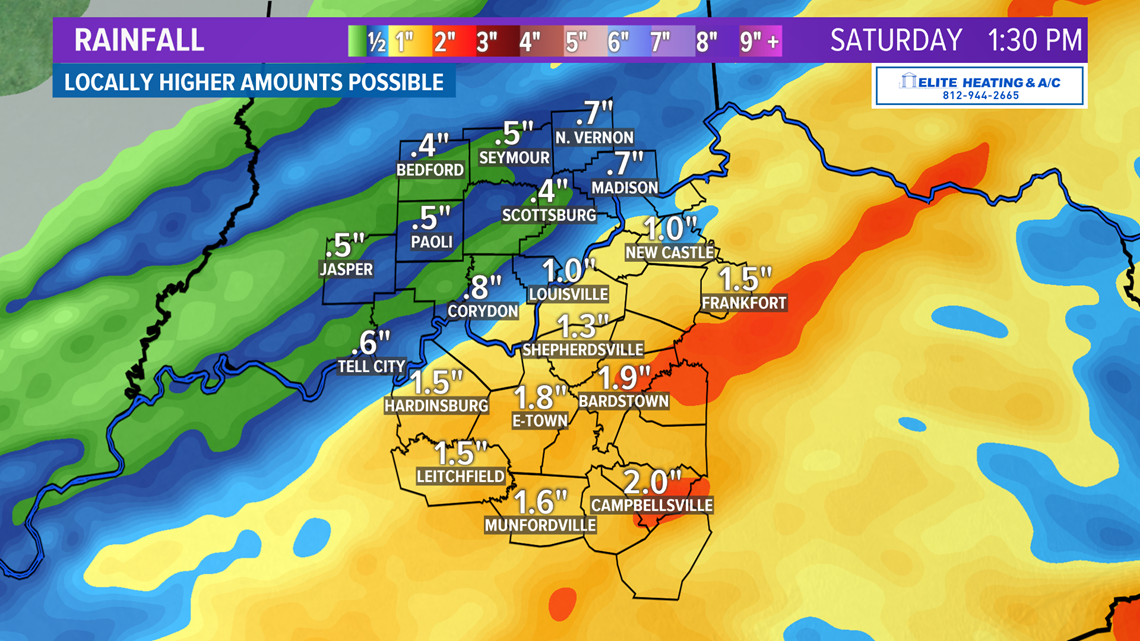
How much rain? Personally, I think our recent rain events have been fascinating as they’ve all been decent soakings. We are again forecasting widespread rain totals of 1”-1.5” with the higher amounts in southern Kentucky closer to the Tennessee border. Southern Indiana will still get a nice drink, but the southcentral are of the Bluegrass State are once again the target for the core of precipitation (Figure 6).

Long term: It’s a bit of a tricky forecast for the first full week. We should see sunshine for Sunday and Monday, but there are some disagreements between the long-range computer models about the middle of the week. There are indications of another potential storm impact the region with both rain and snow possible. We’ll have a better idea of this storm as we get closer.
2019 WEATHER IN REVIEW: What a year 2019 was for weather in Louisville! I went through the records and here are some interesting weather stats I found for the year.
Days max temp ≥ 90°: 80
May (6), June (7), July (23), August (19), September (22), October (3)
Days max temp ≤ 32°: 10
January (6), March (2), November (1), December (2)
Coolest high temp: 22° (January 30)
Warmest low temp: 80° (July 20)
Christmas: New record high of 69°, breaks old record of 68° in 1893
Total precipitation: 53.31” (+8.40”)
Wettest month: February (8.38”)
Driest month: September (0.04”)
Wettest day: 3.01” (November 30)
Greatest snowfall: 2.1” (January 12)
Greatest snow depth: 3" (0.8" January 11, 2.1" January 12)
Highest Temp: 99° (September 10)
Lowest Temp: 3° (January 30)
Days with precipitation (≥0.01”): 130
130/365 = 35.6% of days with rain
Days with ≥ 1” precipitation: 20
February (5), March (2), April (3), May (2), June (2), August (1), November (3), December (2)
Now we wait and see what Mother Nature has in store for us in 2020!
Meteorologist Alden German
Facebook: Facebook.com/AldenGermanWX | Twitter: @WXAlden