LOUISVILLE, Ky. — Big changes are happening in the Pacific Ocean, and it may have big consequences for our weather in the Ohio Valley. A La Niña watch has been issued, indicating the historically strong El Niño we’re currently in looks to be coming to an end, with La Niña potentially returning starting later this summer.
El Niño/La Niña watches are issued when favorable conditions for their development are expected in the next six months.
What are El Niño and La Niña? They’re both part of a larger climate pattern known as the El Niño Southern Oscillation. More specifically, El Niño is a warming of near-surface ocean temperatures off the western coast of South America. La Niña is the opposite of this.
Both phenomena have profound impacts on weather around the world, most notably in winter. We’ve currently been experiencing a historically strong El Niño. In this phase, Kentuckiana and the Ohio Valley generally experience near normal temperatures, but drier than normal conditions in the winter (although not always).
RELATED: El Niño: VERIFY Fact Sheet
The switch from El Niño to La Niña is not sudden, but gradual. There will be a transitional “neutral” period where things are “normal” before we start seeing the impacts of the warmer or cooler equatorial Pacific Ocean waters. As of now, the chance of developing La Niña between June and August is 50%-55%.
Historically, La Niña results in wetter-than-normal temperatures in the Ohio Valley in the wintertime with slightly-above average temperatures. As for spring and summer, we may experience wetter-than-normal conditions with near-to-slightly-above normal temperatures.
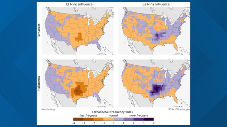
What does that mean for severe weather season? Don’t forget, severe weather season peaks in April and May. Researchers are still trying to understand how La Niña impacts severe weather, but there does appear to be some correlation between La Niña and slightly more frequent hail events in the Ohio Valley, in addition to greater chances of tornadoes.


The increased frequency of these events appears to be much greater in the southcentral and southeastern United States, however. With La Niña potentially not developing until late summer, we may instead find ourselves with a more “typical” severe weather season in the Ohio Valley.
It’s also important to remember that just because we might enter a La Niña this summer doesn't mean we’re guaranteed to see more active severe weather. There are multiple other factors that play a role in our weather.
As of now the chance of La Niña developing is about 50/50, so there is a possibility it doesn’t develop until later than forecast. This is all to say that it’s still too early to have a definite idea of what our severe weather season will be like this year, but this latest development does give us something to think about and keep an eye on in the coming months.
►Contact meteorologist Alden German at AGerman@whas11.com or on Facebook or Twitter.
►Make it easy to keep up-to-date with more stories like this. Download the WHAS11 News app now. For Apple or Android users.
Have a news tip? Email assign@whas11.com, or visit our Facebook page or Twitter feed.
RELATED VIDEO