LOUISVILLE, Ky. — What a Saturday! A squall line – the meteorological term for a very strong line of thunderstorms – rolled through Kentucky and Indiana today bringing high damaging winds, lots of lightning, downpours of rain, and some areas of flooding. This line moved much quicker than anticipated, but that may have worked in our favor in prevent a more significant weather event. Now that the inclement weather has passed, we have a couple of days to catch our breath.
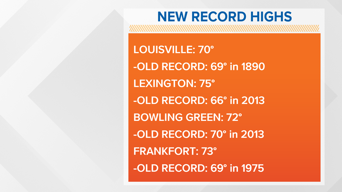
Before we dive into the forecast, let's talk about today's temperatures. Several records were broken today. Louisville broke a record set 130 years ago in 1890! Here's a look at the new record highs for this date:

Forecast at-a-glance:
- We’ll see a couple days of calm weather
- Sunday will be much cooler
- Wet weather returns most of next week
- Temperatures on an up-and-down ride through the week
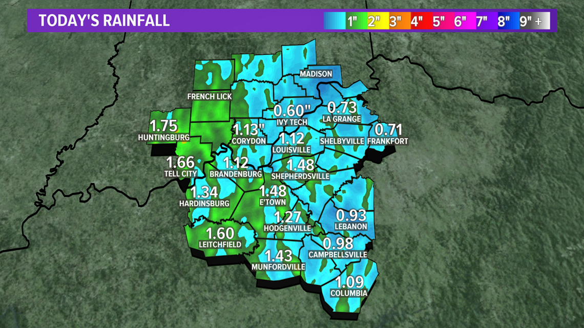
Weather setup: The potent storm system that brought severe weather to much of the mid-section of the country has moved off into Appalachia Saturday afternoon. Over an inch of rain was reported at many of the weather stations in our viewing area (Figure 1). That line of storms was also a cold front that’s brought in much colder air behind it. Temperatures Sunday will be dramatically cooler than Saturday, but still a few degrees above average. Our weather will be calm Sunday as well. When storms systems like this one drag a powerful cold front with them, the cold air behind it dramatically reduces the potential for more bad weather behind it.

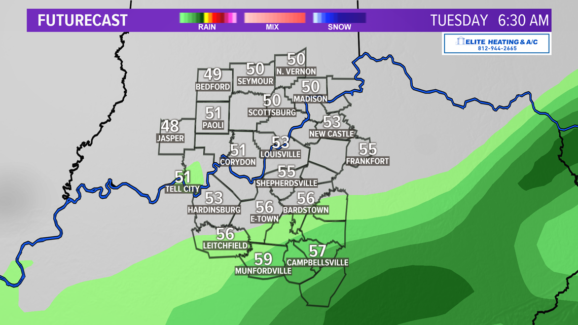
For Sunday and Monday, the eastern U.S. will be a southwest zonal pattern. That means no exciting weather for at least a couple days, but it won’t last long. By Monday night a little disturbance will move northward toward the Ohio Valley and bring again a chance to see some rain. This would likely continue into Tuesday, but the GFS and European models struggle to have the rain to reach the Louisville metro. Compare that to another model, the NAM, which brings the rain further north and places the core of the heaviest rain in southern and eastern Kentucky. For now, central and southern Kentucky are in the best position to see some light rain showers late Monday night into early Tuesday (Figure 2).

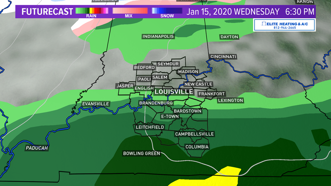
Another shortwave approaches on Wednesday which means, you guessed it, a chance for more rain. This looks like a stronger system than the one we’re expecting Monday so more of the area could see some rain. The European model is much more aggressive than the American model, but both do paint some shower activity in the region. The GFS (Figure 3) leaves the axis of heaviest rain to our south. We'll see how this changes in the coming days as it might trend northward still.
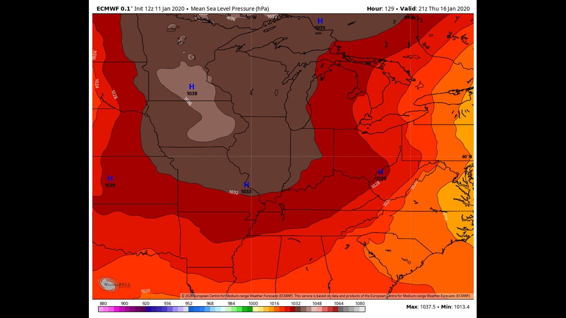
A cold region of high pressure looks settle in Thursday (Figure 4) giving us a temporary break ahead of the biggest storm system of note for Friday and Saturday. It will also bring another steep drop in temperatures from Wednesday into Thursday. We’ll talk about temperatures a bit further down.


Our attention again turns to the weekend when a stronger storm develops and again targets us. There are considerable differences between the Saturday morning American GFS model and the European model runs, but as of Saturday evening they're maybe starting to look a bit more similar. The European has been the more reasonable solution since it paints the Ohio Valley as mainly receiving rain.
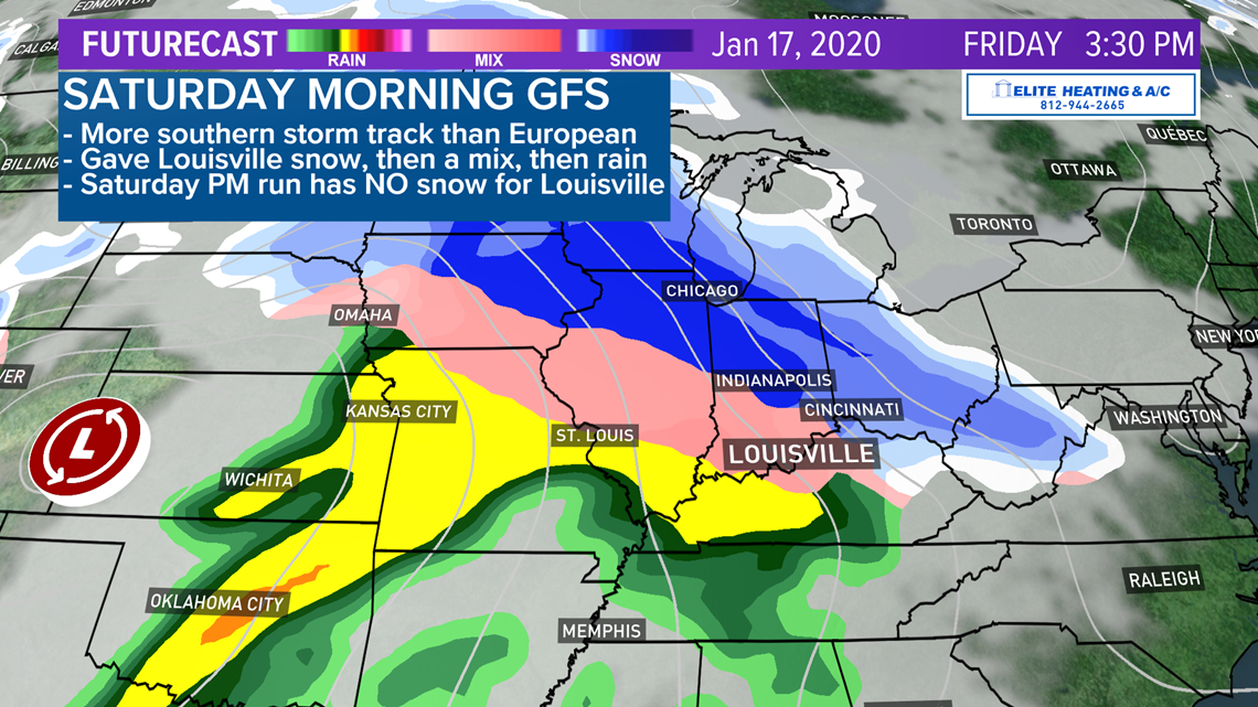
For the sake of transparency I will show the Saturday morning GFS. The Saturday morning run of the GFS gave the Louisville area snow transitioning to ice before transitioning again to rain (Figure 5) and back to snow Saturday evening. Yikes. I was very skeptical of this solution. It placed the center of the storm Friday afternoon significantly further south than the European model, hence why it was trying to give us snow and ice.

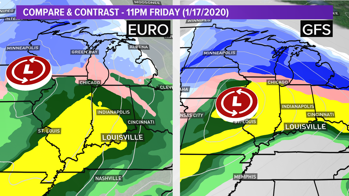
As of Saturday afternoon, however, the GFS shifted the storm track considerably further north so it's more akin to the European model (Figure 6). There will be some variation in track over the course of the week, but seeing the GFS align more similarly to the European so far out leads me to believe the European - for right now - is on the right track.

Temperatures: Despite a cooler Sunday, warmer air will return Monday as temperatures climb back into the middle 50s across the area. This is due to a south wind (also called ‘return flow’) as an area of low pressure develops and moves into the High Plains Monday into Tuesday. This also means temps in the lower 60s again for the early part of the week, but another dramatic drop for the late week when we dip back into the low 40s Thursday. Friday will also be in the 40s, but we may briefly warm into the 50s Saturday depending on the track of the storm. After Saturday, we may finally get some winter temperatures.
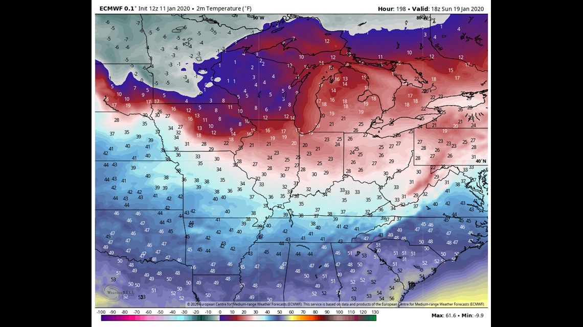
Yeah, where is the winter cold? Still primarily locked away in Canada and the Arctic. If we look super far ahead in the models, namely the GFS since it can actually see that far, a much colder Arctic air mass may arrive behind our potential storm Friday and Saturday. The European is slightly warmer than its American counterpart, but both are showing a potential for some much colder air in the latter half of January (Figure 7).

Meteorologist Alden German
Facebook: Facebook.com/AldenGermanWX | Twitter: @WXAlden