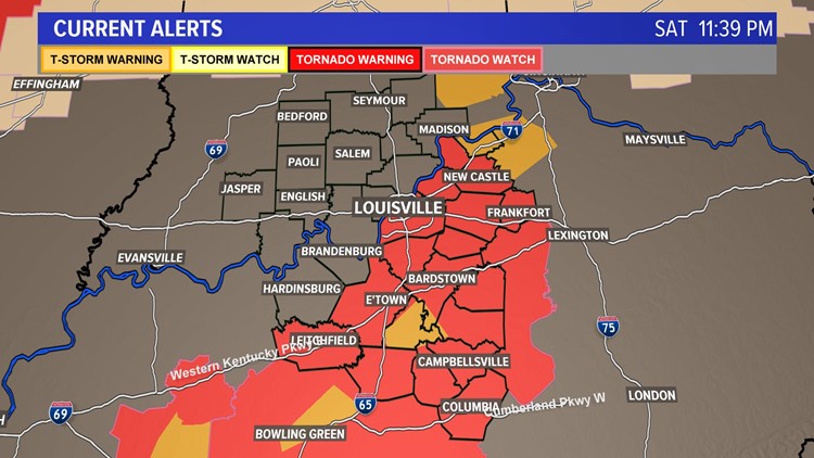
A Tornado Watch is in effect until 3:00am for the following counties:
KENTUCKY: Adair, Breckinridge, Bullitt, Franklin, Grayson, Green, Hardin, Hart, Henry, Jefferson, Larue, Marion, Meade, Nelson, Oldham, Shelby, Spencer, Taylor, Trimble & Washington
A tornado watch means conditions are favorable for the development of severe storms, capable of producing tornadoes. Have a plan and be prepared to seek shelter if a warning is issued for your area.
PREVIOUS
Saturday has brought another day of summer-like temperatures to Kentuckiana, but it also brings a risk for severe weather late tonight into early Sunday morning. Let’s dive into the forecast for through early tomorrow, and quickly preview the rest of the week.
Forecast at-a-glance:
- Temperatures again reached the lower-middle 80s across Kentuckiana, a good 20° above normal
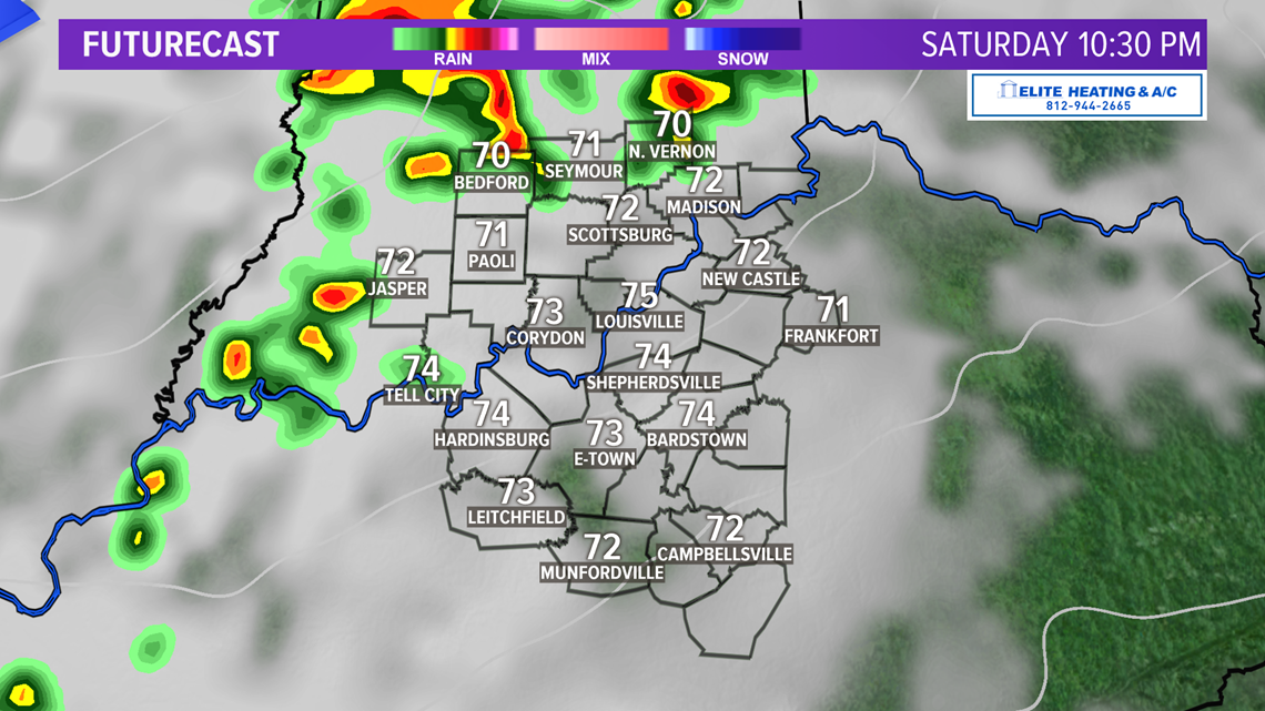
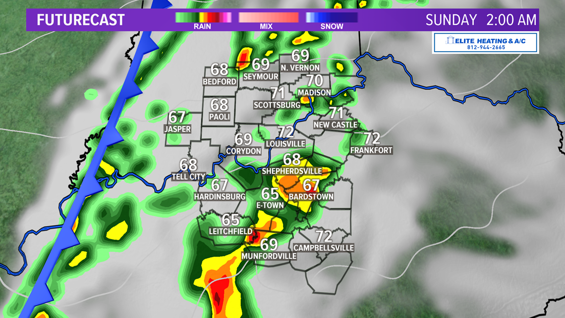
- A line of broken thunderstorms – some severe – is forecast to swing through Kentuckiana tonight
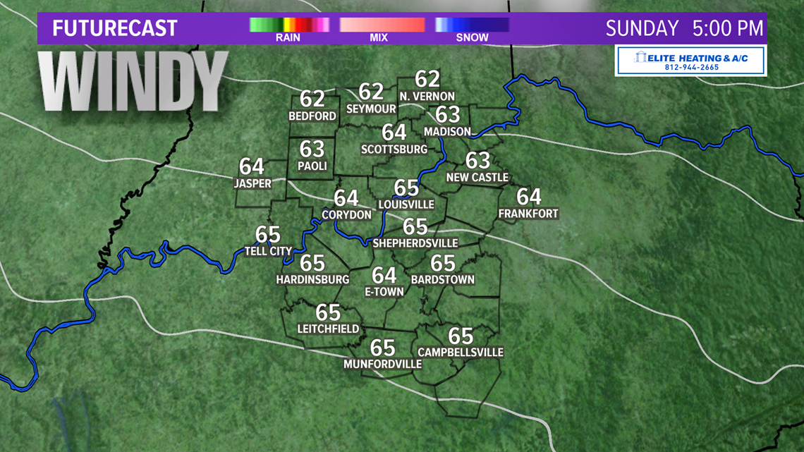
- Breezy conditions will persist through Sunday
- Outside of one additional rain chance, much of the next week looks fairly quiet
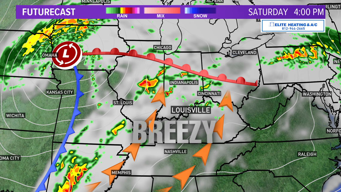
Weather setup: We can thank a large, powerful storm churning in the Great Plains for today’s active weather in the country. The center of the storm will continue to trek northeast into the Great Lakes region. Portions of western Illinois are in the prime spot for potentially numerous long-track supercell thunderstorms that may produce significant tornadoes. Thankfully, we do not have to worry about long track tornadoes.

A warm front to our north is allowing a lot of warm, moist air from the south to surge into the Ohio Valley. Strong southwest winds gusting up to 30 miles per hour today helping our temperatures climb into the lower and middle 80s. Dewpoints will be in the lower-middle 60s, which means it’ll feel a bit humid outside, also providing fuel for thunderstorms later this evening.
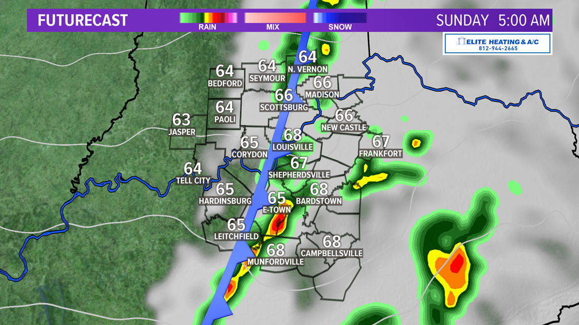
There’s also a cold front draped across the Plains and moving out way. It will be the focal point for a lot of our severe weather potential this evening and tonight. The cold front will pass the region before sunrise Sunday (we’ll get into timing later) and bring drier, slightly cooler weather but keep the windy conditions.
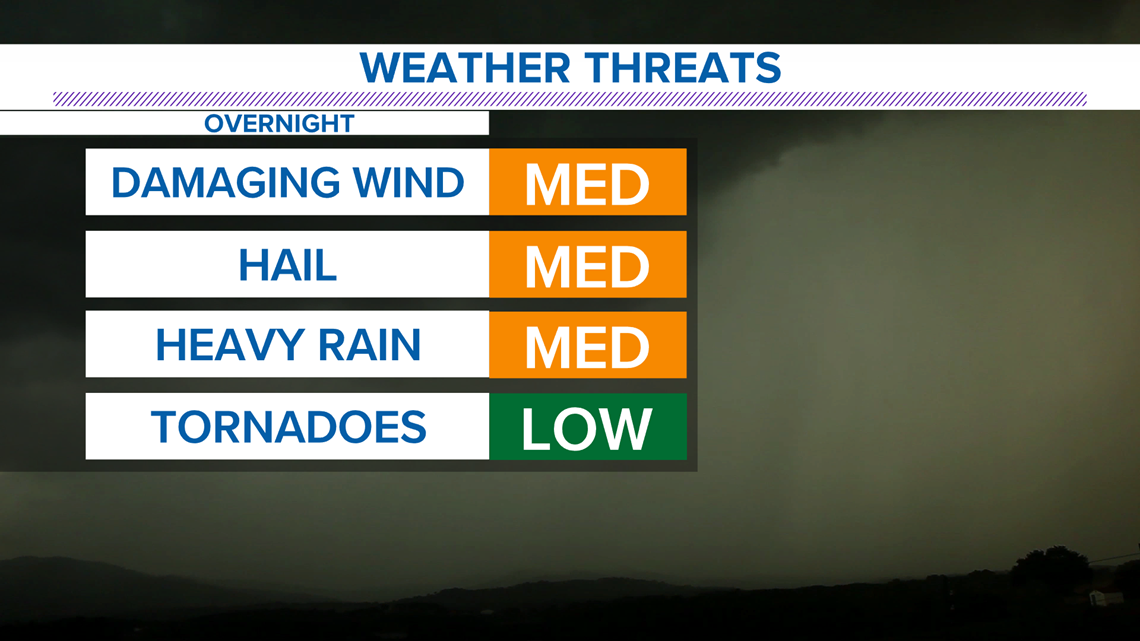
Tonight's severe weather potential: Our weather threat index shows the main hazards tonight are damaging winds, hail, and heavy rain. There’s enough storm fuel in the atmosphere that a tornado is possible, but again, the best potential for tornadoes is well to our northwest. That said, just because the tornado threat is set to ‘low’ does not mean it’s zero. An isolated tornado is possible.
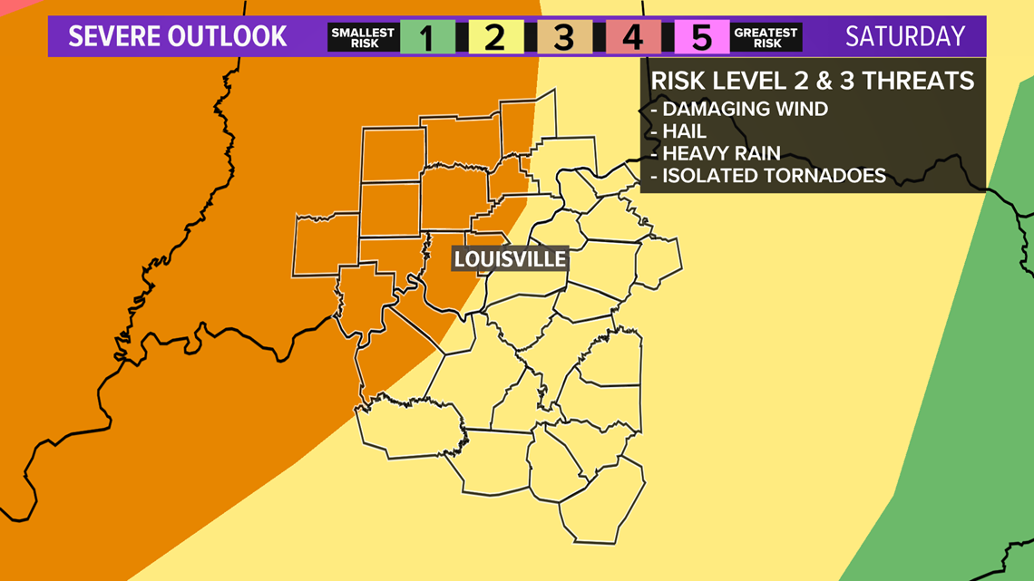
The Storm Prediction Center in Norman, Oklahoma has placed the northwestern third of our viewing area under an enhanced risk for severe weather (level 3 of 5). Louisville is just outside this region in level 2, and the rest of our viewing area is in this level 2 area as well.


Models seem to have slowed the movement of the front and don’t start bringing thunderstorms into the region until late this evening. Storms will increase in coverage and intensity around sunset as they work from west-to-east. Regions west of I-65 can expect storms primarily before midnight. East of I-65 primarily after midnight.


Have a plan: As with any severe weather event, it’s important to have a plan to be prepared, especially true for storms after dark. REMEMBER: tornado sirens are only meant to warn of a potential tornado to people who are currently OUTSIDE at that time. They are NOT meant to warn people indoors, even if you can hear them. Do not rely on sirens alone for tornado alerts. Also, tornadoes at night are particularly dangerous as they are hard to see, many people will be asleep, and it’s difficult to get confirmation of their presence.
This is also a unique situation because of the COVID-19 pandemic, stay-at-home orders, and many closed businesses. If you live in a mobile home, it is especially important you have a plan for shelter. A mobile home is one of the most dangerous places to be during a tornado threat. If a tornado warning is issued, find a more secure building to take shelter in. If you have a friend or neighbor nearby with a basement, ask them if you can take shelter in the event of a tornado.
Severe thunderstorms can also be hazardous, and severe thunderstorm warnings indicate such. Strong straight-line winds can also cause significant damage and have been known to produce wind speeds up to 100 miles per hour.
Have storm reports, photos, or videos? Email them to yourphotos@whas11.com or text them to 502-582-7220.


Long term: Winds will back off Sunday night underneath a mostly clear sky and low temperatures in the middle and upper 40s. Another sunny day Monday! Temps in the middle 60s. Our next chance for rain after tonight comes Tuesday. We'll be a good deal cooler then only managing the middle 50s. After that, we slowly warm back up. 60s should return by Thursday, and we're hopeful for middle 60s come Friday. Models are trying to paint a quick round of precipitation Friday or Saturday. For now, we've left it as a 30% chance on Friday.

Meteorologist Alden German
Facebook: Facebook.com/AldenGermanWX | Twitter: @WXAlden