Hooray! We've survived the first accumulating snow and Arctic plunge of the season! Thankfully it was only a brief taste of winter and not here to stay. We also want to thank you for watching WHAS11 for snow coverage across the region. We work hard to keep you informed during inclement weather so you can plan your life accordingly and thoroughly appreciate your trust in us.
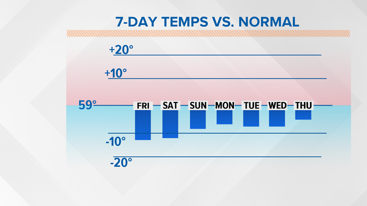
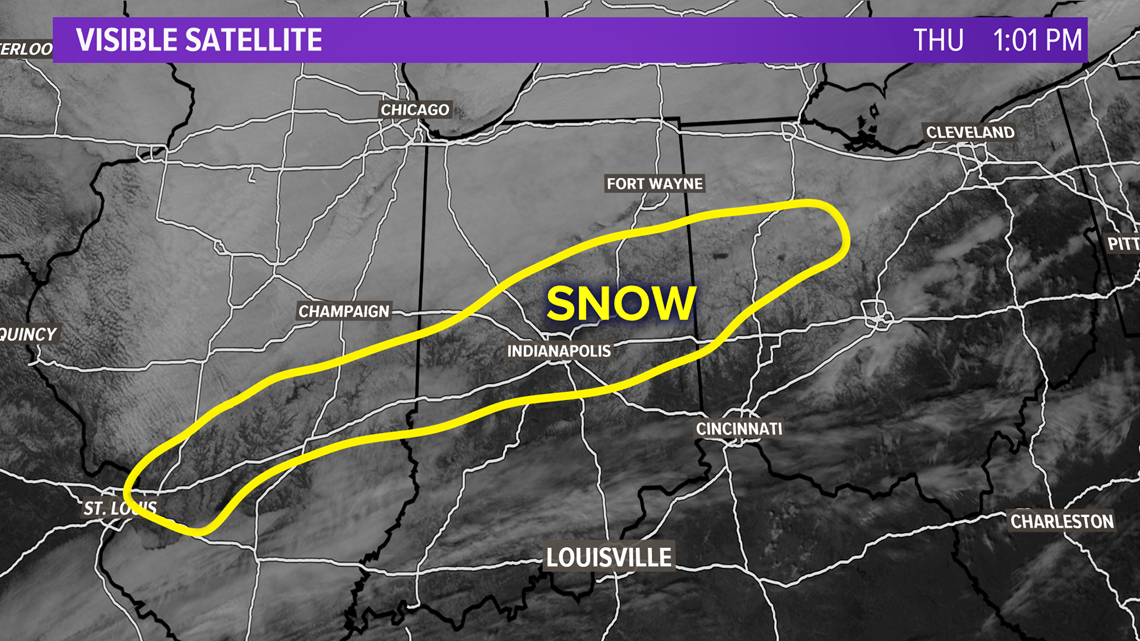
What little snow is still on the ground won't stick around much longer thanks to temperatures in the 40s for Friday and Saturday. There's deeper snow pack in portions of Illinois and northern Indiana, and that will stick around for a little bit longer. It's always impressive to see snow on visible satellite, especially as it slowly melts away.

The weather set up: We can thank the sunny sky and warmer temperatures to an area of high pressure to our west. This has allowed for southwest winds to pump warmer air into the region. A cold front will pass the Kentuckiana region later Thursday night, but this front will be dry. We'll notice it via the shift in winds to the northwest. Mostly clear conditions overnight, plus a relatively light wind and somewhat moist ground from snow melt, sets up an environment that's favorable for fog Friday morning.
Otherwise, the weather pattern shows a ridge (region of higher atmospheric pressure that promotes warmer, calmer weather) in the Midwest traversing east through Saturday. That ridge eventually gives way to a trough (region of lower atmospheric pressure that promotes cooler, more active weather) heading into Sunday. Enter our first chance of rain in the 7 day forecast. Another cold front appears to make a quick visit, but it's not arriving with much gusto. It's really not impressive, and some models keep the region totally dry. While a few sprinkles or a pop up shower are possible, I suspect the majority of us won't see any raindrops. Temperatures aren't really affected by this front either.
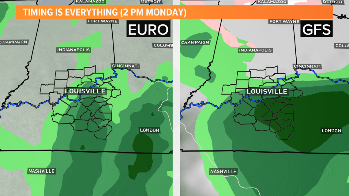
The better chance for rain is next week. First on Tuesday, then later in the week. By Tuesday the eastern half of the U.S. will be under the influence of a trough that will have several small disturbances embedded within it. The position and dynamics of that trough leaves Louisville in a favorable region to see rain. As is normally the case, there are discrepancies between models on timing and scope of this event, but they do agree that there will be rain around Tuesday.

Where things get interesting: Above I mentioned another chance for rain later in the week. That would come Thursday into Friday. While one week is a very long time in meteorology, it still has caught our attention. Note that what you read below is NOT an official forecast; it's simply a discussion about what models are showing for late next week.
At the surface, an area of high pressure over the mid-Atlantic and a broad area of low pressure in the west coast sets up a scenario where warm, moist air (mainly from the Gulf of Mexico) is funneled into the Ohio Valley. In the spring this would mean hot, humid air and a potential for thunderstorms. In the fall and winter this means a potential for warmer temperatures and still a chance for precipitation.

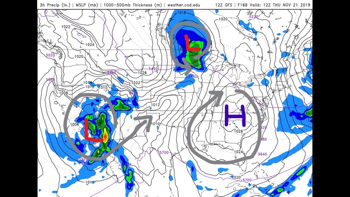
At the same time, a storm system in Canada looks to bring yet another cold front through the Ohio Valley. The cold front from that storm will bring the more impressive looking chance for rain Thursday into Friday. We've only left a slight chance for rain in the 7 Day on Thursday given how far out it is.
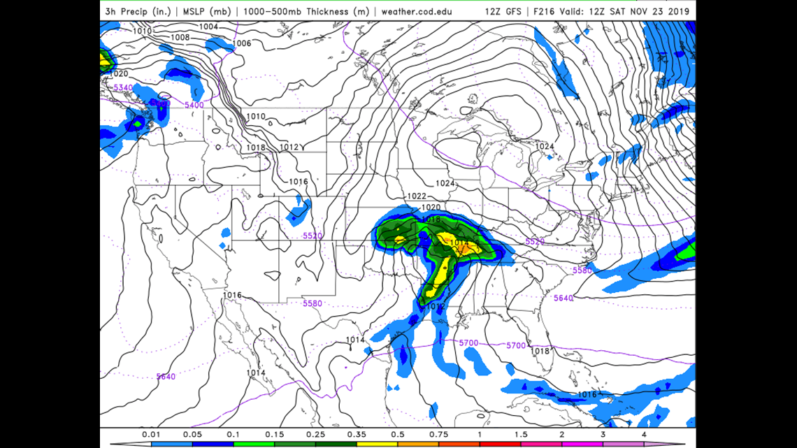
While all of that is happening, the storm off the Baja Peninsula will be moving on shore and lose steam as it traverses the desert southwest. It will come into contact with the Canadian cold front Friday and begin to tap in to the warm Gulf moisture. Once this occurs, the storm would reorganize and follow a path up the Ohio River Valley next weekend (November 22-24).

All of that is still a long time off and of course things will change significantly. In the meantime, enjoy the tranquil and warmer weather.