LOUISVILLE, Ky. — It's almost here, our first snow of the season! You're either giddy about it or dreading it. I can tell people on both sides to not get too worked up over this event, as it's just a small taste of winter and won't last long, but it will still.
The weather set up: The long talked about cold front is still sliding south as of Sunday morning, and temperatures behind it are quite chilly. Temperatures are in the teens in parts of the Dakotas, and that air is making its way toward the Ohio Valley.
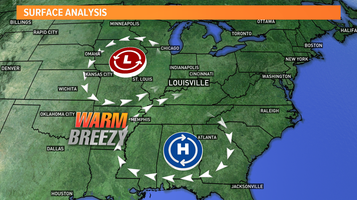
An area of high pressure in the Deep South and an area of low pressure in the Missouri region has set up an air pattern that favors strong southwest winds up the Ohio River Valley. That will pump in warm and moist air for Sunday, allowing temperatures to soar into the lower-to-middle 60s across the region! That's some of the nicest weather we've had in a while, and enjoy it while you can.
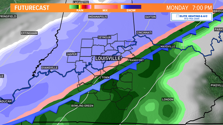
As the front approaches later today, clouds will begin to increase, but we'll remain dry until around sunrise. That's when rain will begin to develop along the front in southern Indiana. As the front continues its trek southward, that area of precipitation will continue to expand. The polar air behind it the front will start to catch up, and by the early afternoon (in Indiana), rain will quickly transition over to snow.
The front will likely move through metro Louisville between 12 p.m. and 1 p.m., and soon after that is when Kentucky will begin to see snowflakes. Current thinking is that snow won't really begin to become widespread until the late afternoon and early evening and last through much of the night before coming to a close around midnight from northwest to southwest.

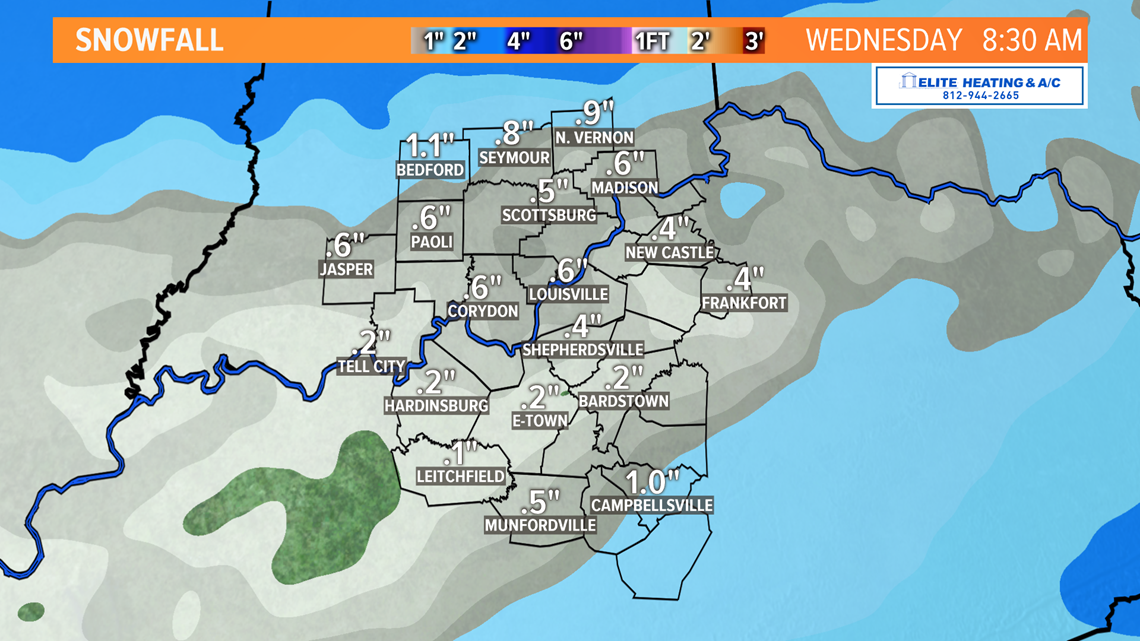
How much snow will fall? Now that we're much closer to the event, all models are coming to a general agreement on amounts. Up to 1 inch of snow is possible in some communities, mainly on grassy and elevated surfaces. Personally, I think it will be tough to reach one inch, but it would be more likely in Indiana where cold air will arrive and snow begin sooner. The ground is still very warm all things considered, so early snow will melt upon contact with the ground. As the polar air settles into place and the immediate surface begins to freeze, snow will start to accumulate. There's a snowfall forecast map (NAM) below, but don't take those numbers as gospel. Totals will vary from town to town and even neighborhood to neighborhood. Travel shouldn't be too significantly impacted by this event, but some icy patches are possible on roads and sidewalks where puddles froze over. Just be cautious of that.
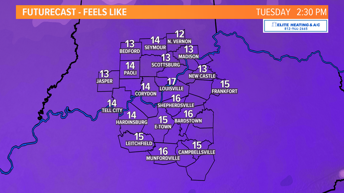
The chill: As we've also been mentioning perhaps ad nauseum, record breaking cold will settle in to the Ohio Valley beginning Monday night. Temperatures will dip into the lower 20s Monday night into Tuesday morning. Clouds are the only thing from preventing us from getting even colder. The thermometer won't rise very much on Tuesday, however. High temperatures will likely be marred in the upper 20s across the region. In these types of situations when a strong cold front with precipitation moves through, clouds tend to linger a bit longer the next day than what models suggest. If clouds do extend their visit, it'll be a struggle to reach the upper 20s. If they get on their way and we see decent sunshine, we may be able to hit 30 degrees.
Regardless, winds behind the front will be northwest in nature and up to 20 miles per hour. This will produce wind chills all day Tuesday in the teens. Yikes. Wind chills in the single digits aren't unreasonable either, particularly in the morning. Temps continue to dive Tuesday night thanks to a mostly clear sky and north wind. Expect lows in the teens waking up Wednesday morning.
The good news: The arctic chill doesn't last long. A broad area of high pressure will take over the eastern U.S.and some warmer air will begin to be pumped in to the region. We'll recover to the mid 30s Wednesday and hover around 50 degrees to close out the week. Another cold front and disturbance looks to swing through Thursday and Friday, but early indications are that this front will be largely dry and uneventful for our area. Any precipitation (likely snow) would be confined to our north in Indiana.
As a reminder, if we fail to hit 32° on Tuesday, it'll be the 5th earliest day with a sub-freezing high temp in Louisville's history. Here are the previous 5:
Louisville's top 5 earliest high temperatures below freezing:
1) November 2, 1954 (32°)
2) November 4, 1991 (32°)
3) November 10, 1913 (31°)
4) November 11, 1894 (32°)
5) November 12, 1932 (32°) could we be adding November 12, 2019 to this spot?