It’s Valentine’s Day. You either love it or hate it. While Friday has certainly been very cold, at least it’s been sunny with no inclement weather. The biggest thing we have to talk about is river flooding in Kentuckiana and only one significant chance for rain in the seven-day forecast.
Forecast at-a-glance:
- Cold snap is short lived as we warm up for the weekend
- A few days of dry weather will help river levels
- Only one chance for rain early next week
- Slightly cooler air returns for the latter half of next week.
Weather setup: A very large area of high pressure was centered near the Ohio Valley early Friday afternoon. High pressure causes air to sink and spread out at the surface. Since rising air is needed for clouds, strong high pressure generally means a sunny sky, light winds, and, depending on other conditions, potentially very hot – or in our case – very cold, weather.
Visible satellite was also a treat for this Valentine’s Day. Recent snows in portions of the Midwest left a thick snowpack across the region forcing temperatures down below zero for lows Friday morning and in many locations potentially staying in the single digits to low teens for highs! Would you believe it if I said snow in north Illinois and Indiana is affecting our weather in southern Indiana and Kentucky? It is!

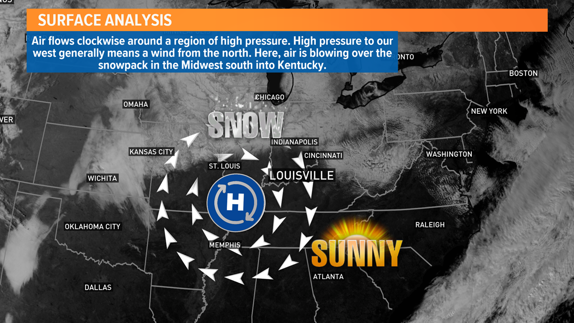
That high pressure I mentioned earlier is situated so a north breeze is across the area. Snow acts as a cooling agent and keeps temperatures much cooler than they otherwise would be. Add in a breeze and that cold air is being blown from its source region (the snow pack) to another location. That’s partially why we were so cold Friday morning! Cold air from snow to our north was being blown overhead, so you can partially blame our snowy friends to the north for today’s weather.
Checking out the atmosphere, our air pattern is mostly zonal through the weekend and to start next week, hence why we’ll see a few days of calmer weather which is going to be good for the river.
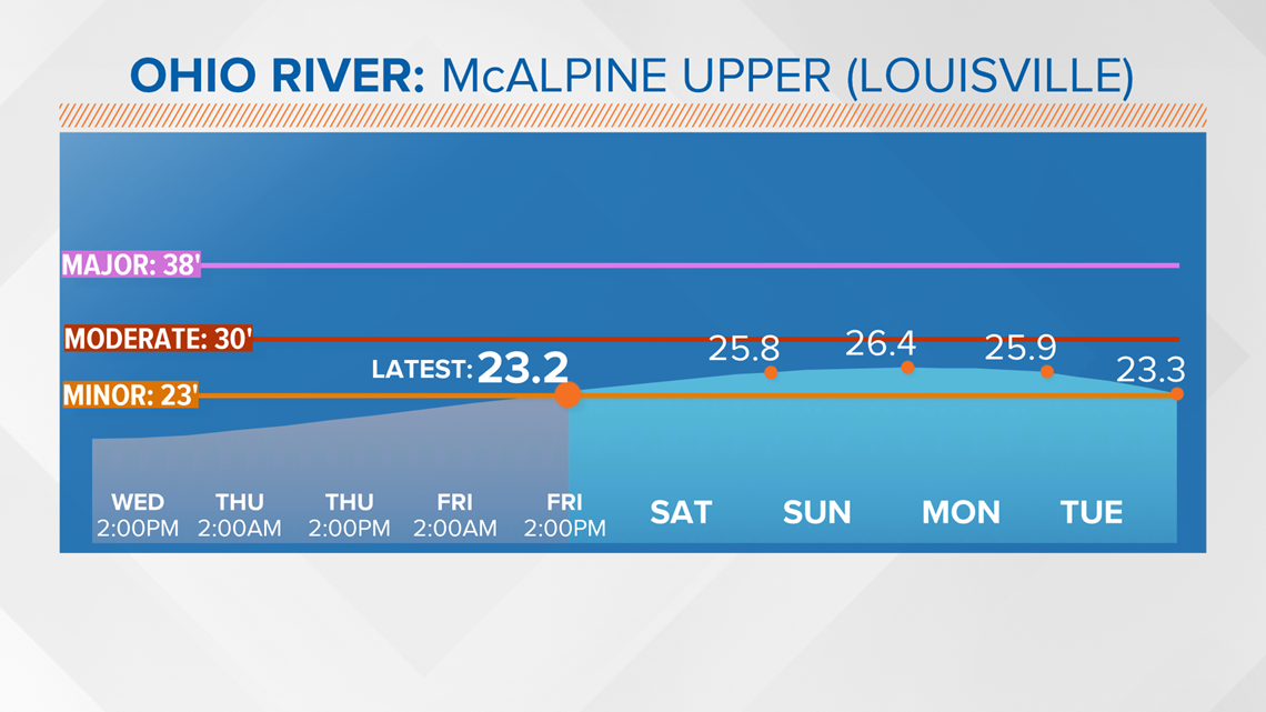
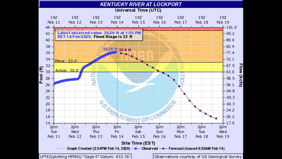
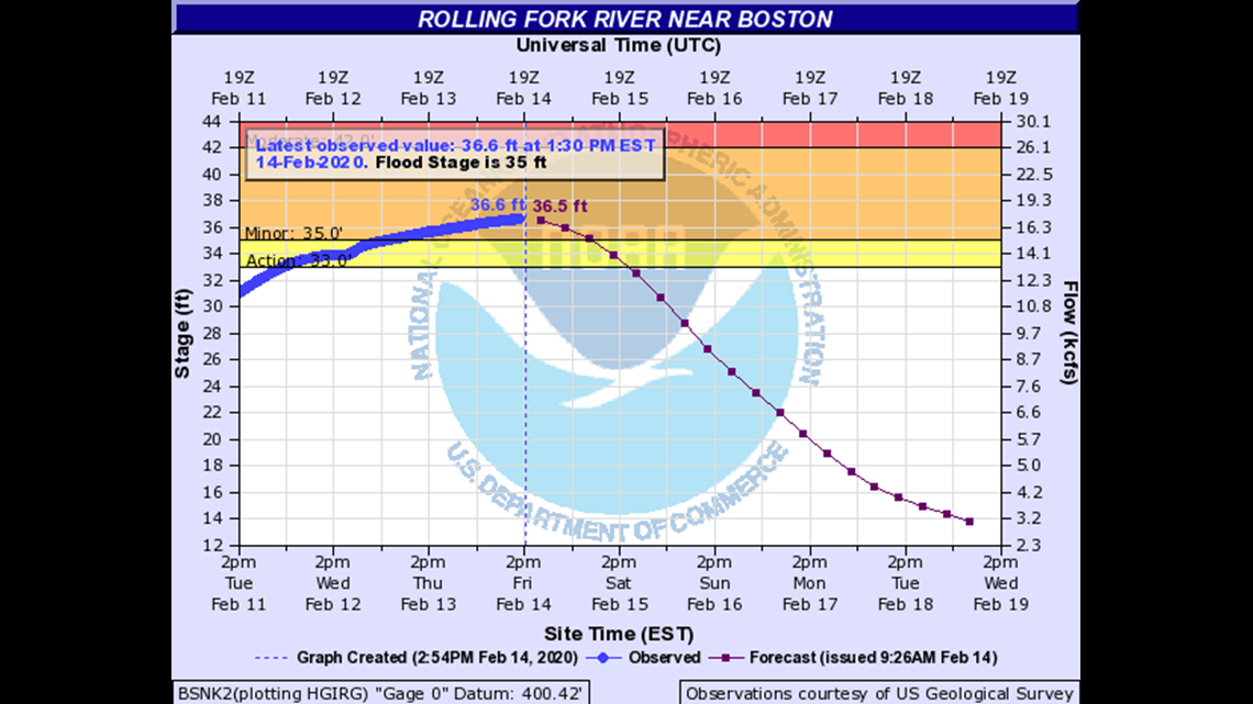
Ohio River Flooding: Historically, Kentucky experiences its worst persistent flooding of the year in February and March and this year is no different. Across the WHAS11 viewing area, the Ohio, Kentucky, and Rolling Fork Rivers all have flood warnings in effect until various times next week. There are two reporting gauges in the Ohio River near Louisville; one near the Illinois Central Railroad bridge and another one near the Sherman Minton bridge.
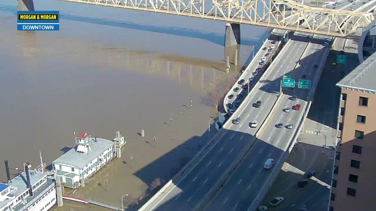
From our Metrocam on top the Galt House Hotel, you can see how high waters have risen along the Waterfront. River Road has been shut down, but thankfully the 3rd Street exit from I-64 West is still open. As of Friday afternoon, the river gauge near the Waterfront is at 23.2 feet. The river is considered to have entered flood stage once it crosses 23 feet, so it's barely over the threshold. You can see in the graphic below that there are three different flood stages: minor, moderate, and major. The Ohio is not expected to flood anywhere near as badly as it did in 2018 when the 3rd Street exit had to be closed. Crest – or the peak river height – is forecast for around 26.5 feet by early Monday morning before slowly receding.

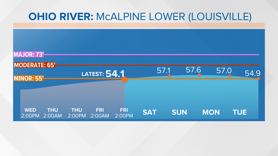
Downriver near the Sherman Minton Bridge, the Ohio nearly doubles in depth. Flood stage here is 55 feet and waters are forecast to briefly jump above flood stage before cresting near 57.5 feet Sunday night/early Monday morning as well. Again, just over the flood criteria.

The Kentucky and Rolling Fork Rivers are in the same boat. The Kentucky River near Lockport is already near its crest and water should start receding as early as Friday night and dip below flood stage by Sunday evening. The Rolling Fork River near Boston is also near its crest and will quickly recede below flood levels by Saturday.


Long term: The forecast is relatively quiet as we start the latter half of February. Monday, despite being mostly cloudy, should bless us with temperatures in the low 60s across the region. This is ahead of a storm system and cold front arriving late Monday night and through Tuesday. Temperatures Tuesday will still be in the upper 50s, so rain is all we’ll see. Precip should start early Tuesday morning and likely give us a wet rush hour before rain comes to an end from west-to-east during the day. That cold front will also bring much cooler air for Wednesday on. Clouds should hang around Wednesday, but temperatures will fall into the lower 40s and persist into Thursday. Thankfully sunshine should return Thursday and Friday.

Meteorologist Alden German
Facebook: Facebook.com/AldenGermanWX | Twitter: @WXAlden