LOUISVILLE, Ky. — Remember yesterday's meme about clouds preventing us from seeing the sun? Well, they gave way a little bit in the evening for a somewhat pretty sunset. They're back in full force now as we see scattered light rain saunter through the region. I'm calling this round one of the rain.
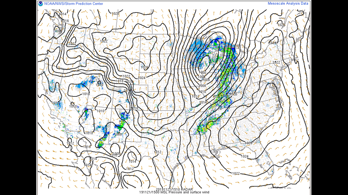
The weather setup: This is rain is part of a mid-latitude cyclone currently centered in parts of Wisconsin and moving into Ontario. The rain is well ahead of a cold front which is currently hanging out in central Illinois (Figure 1). The storm should strengthen a little bit as it treks into Canada.
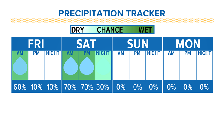
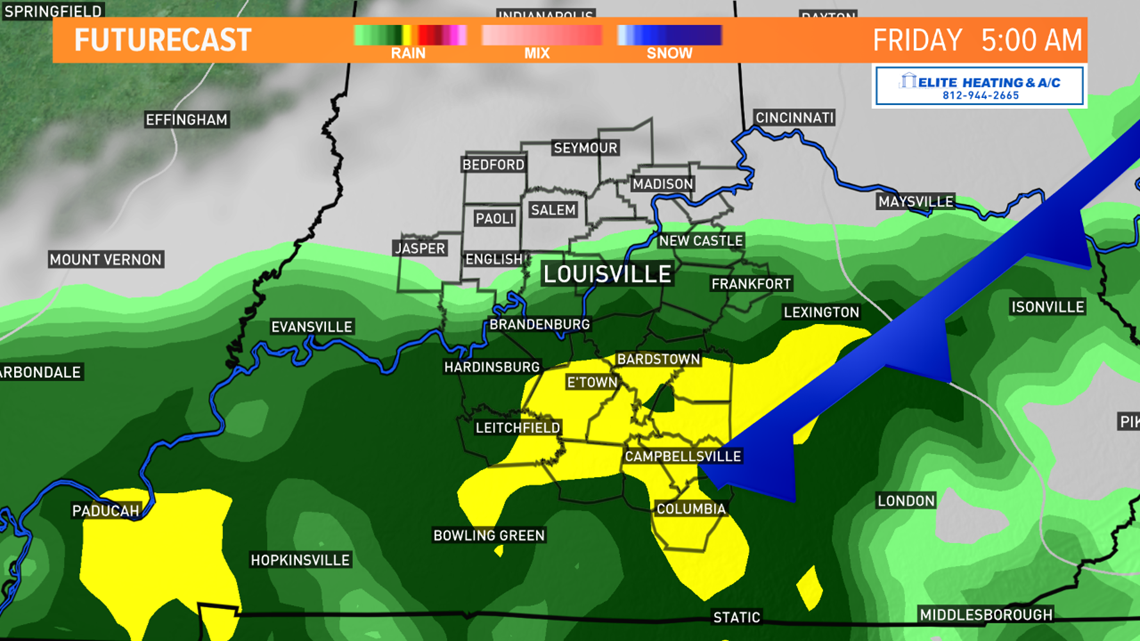
The cold front is moving quite slowly and won't begin to move over Louisville until late Thursday night. As it does, more light to moderate rain will fall. We'll call this round two. The heaviest rain is still forecast to fall over central and southern Kentucky and graze portions of southern Indiana (Figure 2). That rain should come to an end by lunchtime Friday and leave the rest of the afternoon dry with a better chance to see sunshine. The other good news is most of Friday night appears to be dry as well, meaning you might not have to change your nighttime plans.


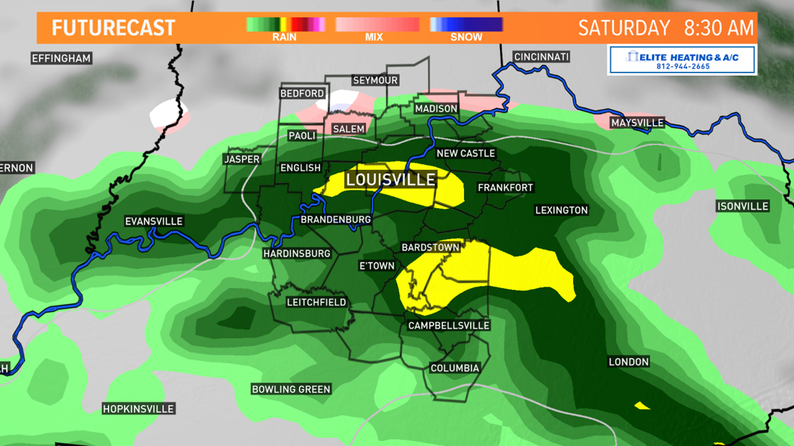
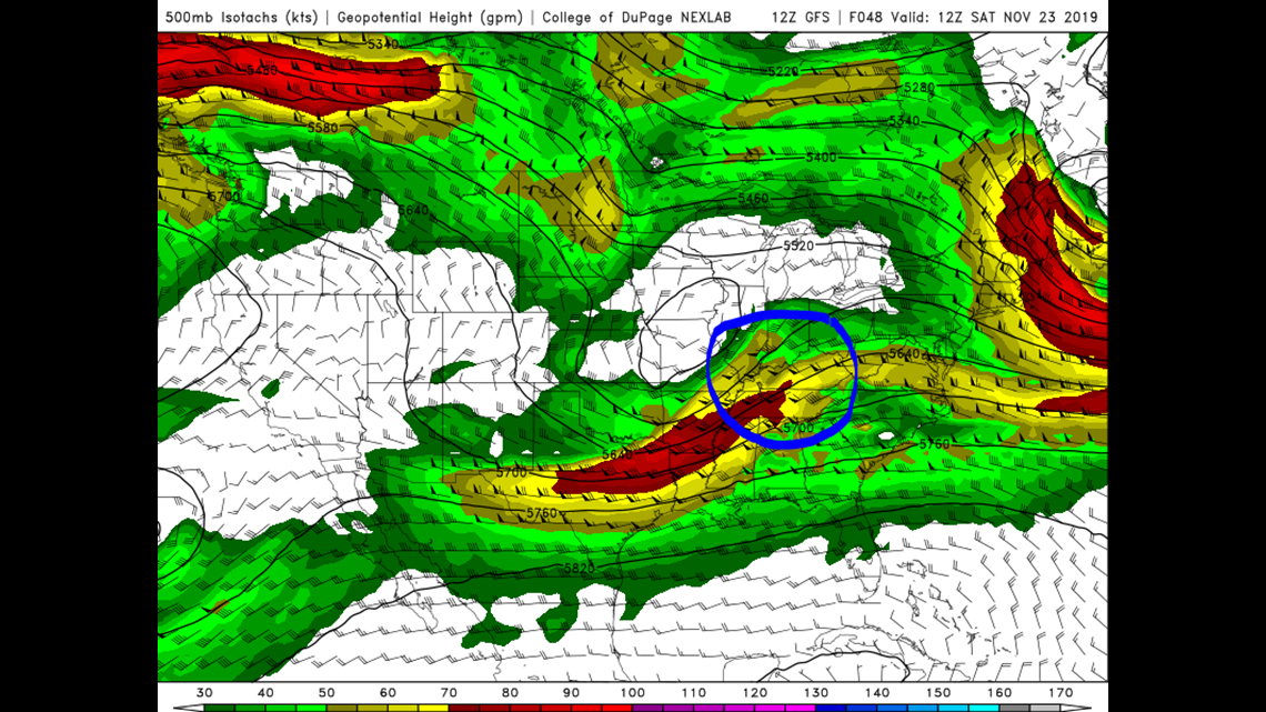
Round three of rain: We're expecting to wake up to more clouds and rain Saturday as another storm system treks up the Mississippi River Valley. This storm is a little more potent, and we're in a good position to see moderate rainfall across all of Kentuckiana (Figure 3). Checking out the 500 millibar (mb) map (500 mb is about the halfway point in the atmosphere), we see that Louisville is on the leading edge of some stronger winds (the yellows and reds). This promotes rising air from lower levels, which can result in rain if conditions are adequate - in this case they are (Figure 4).


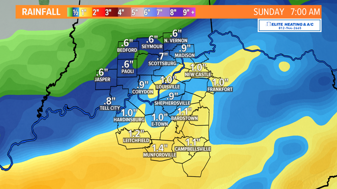
How much rain? A healthy amount is still expected across the area, especially central and southern Kentucky. Southern Indiana might see half an inch to three quarters of an inch once all the precipitation moves out by Saturday evening. The Louisville metro can expect up to one inch of rain, while towns south of Louisville could see anywhere from one to one and a half inches of rain once it's all said and done (Figure 5). Since the rain is falling over a period of several hours, flooding is not a concern. Models are in pretty good agreement about rainfall, only varying slightly in the northern extent of the rainfall.

Looking ahead: No doubt millions of people will be traveling during the week of Thanksgiving for the holiday. We've been mentioning the possibility of a storm affecting travel. Has the existence of the storm changed? No. Has the potential impact from said storm changed? Yes and no. While this storm next week would still produce ample rain across portions of the country, the timing is going to be crucial in whether or not there are many travel delays. First, as of this blog, the day of Thanksgiving looks fine. No rain or snow is expected on Thursday the 28th, and we might actually have a good bit of sunshine across the region. Current guidance suggests this storm would affect the Ohio Valley Tuesday afternoon/evening into very early Wednesday morning. Most of Wednesday itself should remain dry. Keep this in mind if you're planning to travel in the latter half of the day Tuesday.
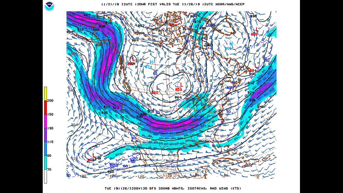
Early indications show a somewhat potent set up for this storm. A broad trough over the western half of the U.S. Monday will allow for a storm to form in the lee of the Colorado Rockies by Monday afternoon. This is a process known as cyclogenesis. Read more about cyclogenesis at this link. As the storm develops, a powerful jet streak will form in the central U.S. and the Louisville region is in a favorable spot to be placed in its entrance region (Figure 6). Jet streaks are a critical factor in storm development, maturity, and precipitation. For more information on jet streaks, their importance, and the charts their found on, just click on this link.

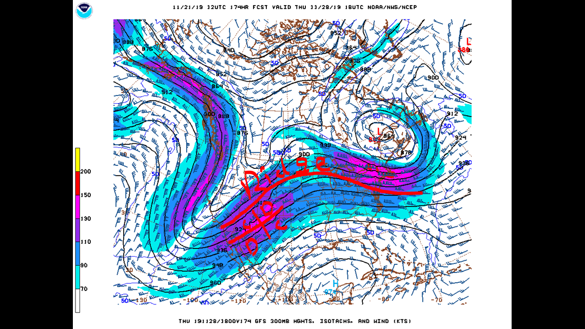
We'll get a better idea on intensity, track, and impacts of this storm later this weekend as the event nears. The GFS seems to be a bit more intense than the Euro with this storm, and they have a moderate disagreement about the track. As I said earlier, Thanksgiving itself looks fine. An upper level ridge will try to develop which hopefully means dry weather and warmer temperatures. That isn't always the case as we've seen the past few days: a small ridge can be in place, but trapped moisture in the lower levels of the atmosphere can form a stagnant stratus deck that is in no hurry to move. There's also the possibility that yet another round of rain could swing through late Thursday into Black Friday. See Figure 7 for the setup on Thanksgiving day and the potential disturbance that could follow it. I've highlighted the ridge and jet streak. Remember to check out that link above to understand what the Cs and Ds mean!

Yeesh. So much going on!
Meteorologist Alden German
Facebook: Facebook.com/AldenGermanWX
Twitter: @WXAlden